





Worldwide Agencies
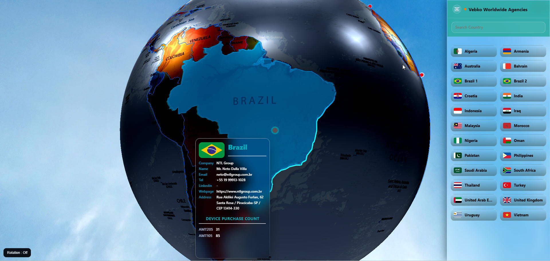
VEBKO Worldwide Agencies is an interactive 3D global map for exploring VEBKO representatives, agencies, customers, and international activity through a visual and searchable interface.
Three.js
Project technology
WebGL
Project technology
Geographic Coordinates
Project technology
Dynamic Information Panels
Project technology
A closer look at the project
VEBKO Worldwide Agencies is an interactive 3D global map for exploring VEBKO representatives, agencies, customers, and international activity through a visual and searchable interface.
From the first need to the final solution
The initial need
The project required a centralized digital platform that could visually communicate VEBKO’s international reach while providing searchable access to agency names, countries, cities, contact details, websites, and related sales or product activity. It also needed to work as an effective presentation tool during exhibitions, distributor meetings, sales sessions, and customer demonstrations.
The main challenge
VEBKO’s representatives and customers were distributed across numerous countries, while their information was mainly available through static lists, documents, and separate contact records. The main challenge was to transform this large geographical dataset into a clear and engaging global view that allows users to quickly identify a country, locate its representative, and access the related agency and market information.
The proposed solution
I developed a data-driven interactive 3D globe in which every agency is connected to geographic coordinates and a structured information record. Users can rotate and zoom the globe, search by country, select markers, and view the corresponding representative details in a dedicated panel. The JSON-based structure allows agencies, contact information, and market data to be updated without redesigning the interface.
The project development process
Dynamic Information Panels
Reviewed VEBKO’s representatives, customers, countries, contact records, sales information, and the requirements of sales and presentation teams.
Agency Data Structuring
Organized agency records into a consistent JSON structure containing country, city, company, coordinates, contact details, websites, and associated activity.
Geographic Coordinate Mapping
Assigned latitude and longitude values to agency locations so that each representative could be displayed accurately on the 3D globe.
3D Globe Development
Created the globe scene, camera, lighting, earth textures, rotation controls, zoom behavior, and geographic marker system.
Search and Country Navigation
Developed a searchable country and agency interface that moves the globe toward the selected location and opens the related details.
Agency Information Panel
Designed a structured panel for presenting agency names, countries, cities, contacts, websites, communication links, and available commercial information.
Selected images and videos
Project Image
Project Image
Project Image
What this project delivered
The final result is a reusable, responsive, and visually engaging global-presence platform that converts VEBKO’s international network into an accessible digital experience. It helps customers understand the company’s worldwide reach, allows potential buyers to locate regional representatives, and gives sales teams a professional tool for demonstrating international activity during meetings and exhibitions. The system can operate independently or as an embedded module inside other VEBKO platforms and can be expanded by adding new agencies, countries, contact records, and commercial data.
Let’s build a clear and effective digital experience.
From technical content and visual communication to websites, interactive systems, and automation.